Big 4 and Monte Cristo area, July, 2003!
All photos taken by me.
(Just thought I 'd throw that in) : )
After finding Sperry Peak so nice last year, I made yet another trip to the area on
July 10, 2003. This time I was intent on following a book author's "three easy hikes
in the Barlow Pass area" guide, which is just a few miles from Sperry Peak. My first
hike was to the ice caves at Big 4 Mountain. My brother and his family went there last year
and said it was a nice hike. The hike in had me swatting flies, mosquitos and bees, which
seem to like my camera bag. The trail starts off in a marsh, walking on a very well
maintained trestle. It was so quiet, I could hear the dragonflies blow-drying their wings.
The next stage of the hike was forest and, as is typical of the western Washington, thick
underbrush and moss covered trees were in order.
As I came closer to the mountain, the tall trees made way for shorter trees, shrubs, flowers
and grass. At the base of the mountain is a large patch of snow/ice. As warmer air flows
underneath the ice, it creates tunnels, called the ice caves. I saw two of them today, and
approached one of them.
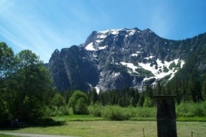
Big 4 Mountain. (This picture was taken 6/22/2002.)
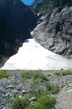
This is the large patch of ice/snow that forms the ice caves, two of which can be seen
at the bottom.
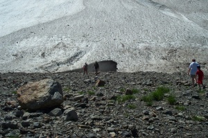
As I got closer to one of the ice caves, I could see how big it was when other hikers
walked up to it. It was about 5 to 5-1/2 feet tall, and about 10 feet wide.
Compare it's size to the previous picture and you can see how big the ice/snow patch is!
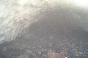
As it blows out of the ice cave, the cool, moist air turns to fog. It was
hard to see very far into the cave.

I crouched down and walked into the cave about 15 feet. I didn't want to go in further,
because signs warn that people have been injured by collapses. Dave's a chicken...
Water was dripping from the ceiling, and along with the cool air, it was quite refreshing. The
outside temperature was in the 80s!
It looked like the cave took a turn about 30 feet inside -- beyond that, I don't know.
** UPDATE ** September, 2003:
My friend Greg and I hiked back to the ice caves in mid-September. This late in Summer,
the caves were a bit larger, with an interior ceiling of about 15 feet high. Two of the
caves had merged into one and I was going to walk through them, but chickened out: I
was spooked by the piles of collapsed ice lying along the edge of the caves.
****
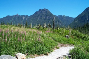
On the way back to the truck, I took pictures of some nearby grass and flowers.
After the Big 4 hike, I went to hike either Government Trail and/or the Barlow Point Trail.
Both trails start from the same trailhead. I walked about 1/4 mile and found the trail
was beginning to become more difficult than I was prepared for. Here I am, out of shape,
hiking alone on chipping slabs of volcanic rock, and I don't have any kind of first aid or
water. So, I decided to save this hike for another day when I'm better prepared.
I had a backup hike, though! I hiked part of the Monte Cristo Trail, instead. I had
information that a bridge had washed out a little more than a mile into the hike and
decided I would proceed on the trail up to that point. This trail was a former railroad grade
(and thus very flat) and had been used by autos up until a major washout in 1980. They
repaired the washout, but I guess the frequency of that and similar washouts and damage
caused by the neighboring Sauk River drove the government penny counters to close the road
to autos. The lack of cars made for a nice quiet hike: I passed only four other people and
they were all on bikes.
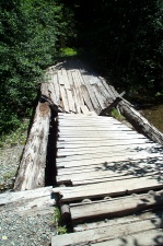
At the place where the bridge was damaged, I found two bridges. The first was still in
use for people. The second bridge (above) appeared as if it had collapsed under the
weight of a vehicle. There's a detour nearby, but it requires traversing a fork of the river.
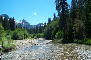
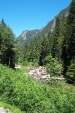
More from the Monte Cristo area. This picture was taken while standing on the first of the
two bridges.
More from the Monte Cristo area.
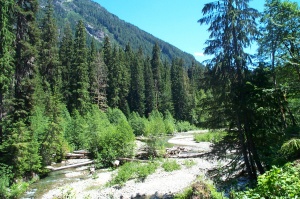
More from the Monte Cristo area. This was taken from the site of the 1980 washout.
- 30 -
Images: © 2002-2003 David M Martin
XHTML: © 2003 David M Martin